Photo Courtesy of the Tribune Weekly Chronicle Blogspot
Little did I realize when I developed our shooting schedule for Oklahoma that May is a big month for tornadoes. And there have been quite a few already in April in the worst outbreak since 1974 in the south. Not being used to these we will have to learn what to do if we see one approaching. Oklahomans live with this all the time. To my scientific side it is an amazing albeit destructive act of nature's awesome power.
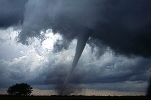
A tornado is a violent, dangerous, rotating column of air that is in contact with both the surface of the earth and a cumulonimbus cloud or, in rare cases, the base of a cumulus cloud. They are often referred to as a twister or a cyclone[1], although the word cyclone is used in meteorology in a narrower sense, only to name hurricanes or typhoons. Tornadoes come in many shapes and sizes, but are typically in the form of a visible condensation funnel, whose narrow end touches the earth and is often encircled by a cloud of debris and dust. Most tornadoes have wind speeds less than 110 miles per hour (177 km/h), are approximately 250 feet (80 m) across, and travel a few miles (several kilometers) before dissipating. The most extreme can attain wind speeds of more than 300 mph (480 km/h), stretch more than two miles (3 km) across, and stay on the ground for dozens of miles (more than 100 km).[2][3][4]
Tornadoes have been observed on every continent except Antarctica. However, the vast majority of tornadoes in the world occur in the Tornado Alley region of the United States, although they can occur nearly anywhere in North America.[7] They also occasionally occur in south-central and eastern Asia, the Philippines, northern and east-central South America, Southern Africa, northwestern and southeast Europe, western and southeastern Australia, and New Zealand.[8] Tornadoes can be detected before or as they occur through the use of Pulse-Doppler radar by recognizing patterns in velocity and reflectivity data, such as hook echoes, as well as by the efforts of storm spotters.
A tornado near Anadarko, Oklahoma. The funnel itself is the thin tube reaching from the cloud to the ground. The lower part of this tornado is surrounded by a translucent dust cloud, kicked up by the tornado's strong winds at the surface. Note that the actual wind of the tornado has a much wider radius than the funnel
Check out Rob Haneisen's blog, Weather Geek for his story about an encounter with a tornado.


No comments:
Post a Comment